Mapping the Latino Population, By State, County and City
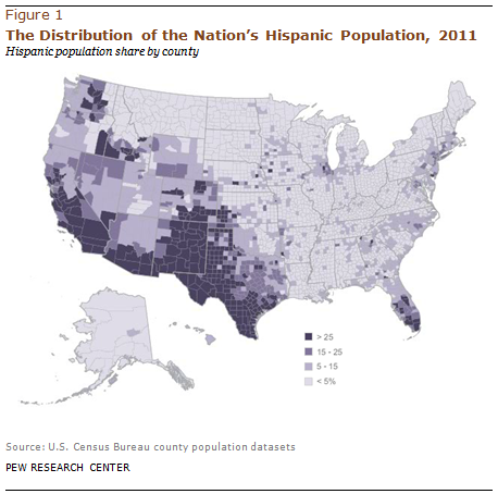
Mapping the Latino Population, By State, County and City
Read the report!

 The Pew Research Center's Hispanic Trends Project annually produces reports, databases and interactive maps showing the current geographic concentration of Hispanics throughout the U.S. and how that distribution has changed since 1980.

These maps and databases are largely based on the most recent data from the U.S. Census Bureau's American Community Survey. Accompanying these maps are statistical profiles of the Hispanic population in each of the 50 states and the District of Columbia along with statistical profiles of the Hispanic population in the 60 largest metropolitan areas.

View the full report and interactives on the Pew Research Center's Hispanic Trends Project website.

Downloads Full Report
America’s Overdose Crisis

America’s Overdose Crisis

Sign up for our five-email course explaining the overdose crisis in America, the state of treatment access, and ways to improve care

Sign up
Quick View

America’s Overdose Crisis

Sign up for our five-email course explaining the overdose crisis in America, the state of treatment access, and ways to improve care

Sign up
Composite image of modern city network communication concept

Learn the Basics of Broadband from Our Limited Series

Sign up for our four-week email course on Broadband Basics

Quick View

How does broadband internet reach our homes, phones, and tablets? What kind of infrastructure connects us all together? What are the major barriers to broadband access for American communities?