Washington State Floodplain Manager Discusses Program That’s Helping Communities, Environment
Floodplains by Design partnership works across jurisdictions to lower disaster risks and restore ecosystems

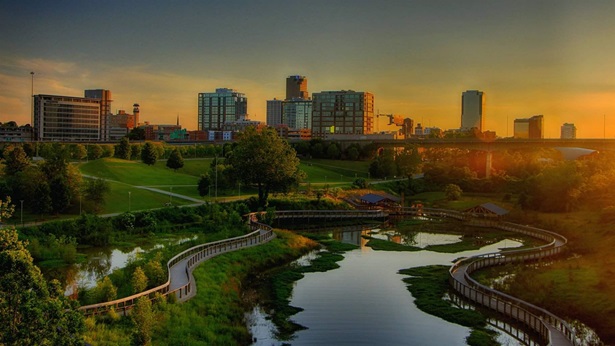
As Washington’s statewide floodplain manager, Gordon White works to limit the impacts of flooding across the state, including directing the Floodplains by Design program. Since 2013, the Washington Legislature has appropriated $165 million to fund the program, a state partnership with the Nature Conservancy. The program has reconnected about 2,500 acres of floodplains, protected 500 acres of farmland, restored more than 25 miles of salmon habitat, and removed nearly 700 residences from high-risk flood zones in 38 communities.
The Pew Charitable Trusts asked White five questions about Floodplains by Design and how other places can follow Washington’s lead. This article has been edited for clarity and length.
Q: What spurred the creation of Floodplains by Design?

A: Here in Washington, we have an 80% chance of 10 or more floods in any given year. In western Washington, most floods happen after prolonged winter rains. In eastern Washington, spring mountain snowmelt and rain-on-snow events often cause flooding. Eastern Washington is also more prone to flash floods. We also face coastal storm surges, overwhelmed storm drains, ice jams and debris blockages, and migrating river channels. And we’re experiencing the effects of climate change: Winter storms are getting stronger and more frequent, while our summers are hotter and drier.
We have 62 watersheds and our floodplains provide important habitat for our salmon, rich soil for our farms, and beautiful backdrops for our lives. During European settlement times and continuing through statehood, we attempted to control rivers, thinking flooding could be simply stopped by walling off rivers, straightening them, and laying out development across them. These methods destroyed salmon runs, were costly to maintain, and flood disasters became more threatening. We knew we needed a different approach.
Floodplains by Design was created to reduce flood risks while restoring aquatic habitat. It promotes “integrated floodplain management” in which tribal governments and all other stakeholders are engaged, seeking holistic outcomes with enduring solutions. We use a competitive grant process to fund projects.
Q: Why does Floodplains by Design focus on projects that address flooding across jurisdictional lines?
A: The answer is as simple as the problem is complex: Rivers and floodplains don’t follow political jurisdictions. For a nature-based, multibenefit program to succeed, all communities along a river and its floodplain must work in partnership. When communities, tribal governments, farmers, and others advance each other’s needs for a healthy river and vibrant floodplain, they become a “happy family.” This is different than merely compromising. Floodplains by Design is designed to be a long-term commitment, often taking years to achieve solutions.
Q: What’s an example of a project that reduced local flooding?
A: A great example is the Puyallup Watershed Floodplain Reconnection project in Pierce County. The 45-mile-long Puyallup River originates from glaciers on Mount Rainier and flows northwest. About 500,000 people reside in the 950-square-mile watershed, which has a thriving agricultural community.
A century ago, about 52 miles of levees were built to confine the river in a narrow channel. The levee system, however, was not designed to withstand today’s higher water flows and now needs constant and expensive maintenance. Flooding has increased and salmon populations are at severe risk.
With $9.2 million in Floodplains by Design funding, a diverse group of partners developed and began implementing a 10-year vision for the watershed and the change has been transformational. Farmland easements are safeguarding agricultural lands; acquisitions and relocations are making residents safer; a restoration project is improving drainage and fish habitat; and a drainage inventory is in progress.
In the past when the Puyallup River flooded, water went into schools and neighborhoods. The watershed reconnection project re-widened the river and constructed a $16.7 million, 8,100-foot setback levee near the town of Orting. In November 2014, we had the fourth-largest flood on the Puyallup since 1962. The newly opened floodplain was able to absorb the flood flows, just as nature had originally designed! Orting stayed high and dry.
Q: How does Floodplains by Design forge partnerships to accomplish its goals, despite pressure to build homes in floodplains?
A: Floodplains by Design brings residents, local and tribal governments, farmers, fish recovery, and conservation organizations together to plan for development, protect floodplain functions, and restore and preserve aquatic habitat. Different approaches are encouraged but they’re working together with common goals and principles so they don’t put people and structures in harm’s way in the first place.
Communities consider Floodplains by Design projects that include specific elements such as helping return natural floodplain functions to control flooding and erosion, filtering pollutants and cleaning drinking water, and restoring and protecting wetlands and shoreline habitats while offering important places for people to boat, fish, and recreate. Since we use a competitive grant process, to win funding applicants must show they are striving to use integrated floodplain management approaches to reduce flood risks that also restore the ecosystem.
Q: What advice do you have for decision-makers in other states who are searching for resources to mitigate flooding in their communities?
A: The best advice I can offer is to keep in mind the three P’s—partnership, partnership, partnership. Bringing diverse groups together to advocate for one another helps ensure that the investment will have a high, multibenefit return. Work with nature and the natural processes in a floodplain—not against them. We’ve spent decades throwing good money after bad trying to fix problems. Now it’s time to invest in solutions that will appreciate, not depreciate, over time.
Make the case. For every $1 invested in flood prevention, there’s a $4 to $7 return. That’s money residents, business owners, farmers, and local and tribal governments don’t have to spend on rebuilding, restoring, and replacing losses from floods. Keeping people safe, infrastructure and habitats protected, and transportation corridors open is invaluable.
Finally, I heartily recommend embracing new initiatives like FEMA’s Building Resilient Infrastructure and Communities and NOAA’s Coastal Resilience Grant program. These programs can help leverage local investments by providing resources to identify flood hazards, plan a more flood-resilient landscape, and complete projects that reduce flood risk to life and property.


ADDITIONAL RESOURCES

Fact Sheet
Fact Sheet