New Analytic Tool Can Aid Strategic Land Conservation
Models and maps uncover smart measures to connect protected areas
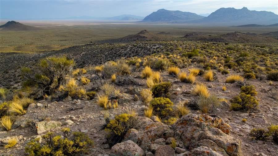
Typical basin-and-range geology found in Nevada, where the north-south orientation of the landforms seems to encourage movement between northwestern and southwestern states.
Bob Wick, BLM
Scientists have developed a new tool to help identify which unprotected public lands offer the best opportunities to connect safeguarded areas across the western United States. The tool’s models and maps can be used to make critical decisions on how to best link and protect vulnerable habitats across broad areas.
The fundamentals of conservation biology suggest that large, intact landscapes are needed for a system of protected areas to function ecologically. Connecting those areas is critical to conserving and enhancing biodiversity within the borders of individual areas and beyond. Although the United States has an extensive collection of protected areas—including very large units such as Yellowstone National Park, Idaho’s Frank Church-River of No Return Wilderness Area, and Utah’s Grand Staircase-Escalante National Monument—this collection currently is more an assemblage of isolated areas than a network of protection.
New research, led by Brett Dickson of Conservation Science Partners (CSP), explores how models and maps can provide key information about how to best link vulnerable habitats across expansive landscapes, shielding biodiversity and other important ecological functions from climate change and expanding human development. The tool, developed by CSP and colleagues with The Nature Conservancy, Northern Arizona University, and the University of Wisconsin, is the subject of an article by multiple authors published today in Conservation Letters, a journal of the Society for Conservation Biology. Funding for the study was provided by Pew, with additional support from the Interior Department’s Southwest Climate Science Center.
The new research should help land managers and the conservation community to focus specifically on the places most likely to provide effective links when considering how to connect these already protected areas, making it possible to strategically and efficiently select the best areas to strengthen America’s network of conserved lands.
According to the research, in comparison with other lands across the West, those supervised by the Bureau of Land Management “disproportionately constitute the ‘connective tissue’” among protected areas and other lands in many jurisdictions. Unprotected BLM lands, which are frequently found adjacent to conserved areas, generally have fewer barriers to the movement of organisms, or what the article calls “ecological flows,” such as steep slopes, roads, and other human development. The qualities suggest that strategically conserving these BLM lands could do more to promote linkages than new protections on other federal lands.
The research notes that BLM designations offer a pre-established mechanism to connect high-priority areas. For example, Areas of Critical Environmental Concern (ACECs), which are authorized in the BLM’s governing law (the Federal Land Policy and Management Act), can be proposed to protect natural systems and processes.
The researchers found the highest level of ecological flow in southern Oregon and Idaho, northern Arizona, and central Utah. Steady flow is also found in Nevada, where the north-south orientation of the basin-and-range landforms seems to encourage movement between northwestern and southwestern states. Areas in southern Idaho and the deserts of Southern California and western Arizona also show good connectivity patterns that may be due to their proximity to protected areas such as Death Valley National Park.
The article outlines a “flow-based model of ecological connectivity” that operates in much the way electronic circuit theory predicts the movement of electricity through a system in which it may be slowed by resistors such as volume control or a lamp dimmer. The study quantified the “resistance” of the western landscape, namely, how natural barriers (such as steep slopes and rivers) and human activities (like roads and other development) might affect the movement or migration of wildlife and plants. The analysis also incorporates an earlier CSP study of high-value conservation areas derived from various ecological indicators—such as topography, water surface availability, and a rich variety of species.
This tool should ensure that protective measures can be effectively targeted to the most efficient acreage, boosting efforts by conservation advocates and federal agencies, particularly the BLM, to identify linkages that need to be conserved while reducing conflict among land users. Because the BLM is preparing to incorporate greater consideration of ecological processes on a landscape scale as part of its land use planning process, the tool could not have come at a better time.
Ken Rait directs the western lands initiative for The Pew Charitable Trusts.


ADDITIONAL RESOURCES

Article

Article