Arctic Vessel Traffic in the Bering Strait
OVERVIEW
The Bering Strait, approximately 44 nautical miles wide at its narrowest point, is the Pacific gateway to the Arctic Ocean. The movement of water and seasonal sea ice and the presence of a shallow continental shelf create a highly productive marine ecosystem. Almost the entire western Arctic population of bowhead whales travels through the strait twice a year. It also provides important food for the Pacific walrus, spectacled eider, and gray whale. An estimated 12 million seabirds nest or forage in the area each year. The strait is also home to indigenous communities whose inhabitants have lived a traditional way of life along its shores for untold generations. This history gives them great knowledge of the region, its ecosystem, and its diverse wildlife. For many residents of the Arctic, the continued health of the marine environment as well as their subsistence way of life and cultural well-being are inextricably connected.
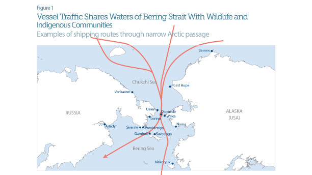
Vessel traffic through the Bering Strait has been increasing steadily. The growth in Arctic marine operations is due in large part to natural resource development made possible by diminishing sea ice and the region’s growing ties to the global economy, trends that are expected to continue. Although shipping activity is light compared with other industrialized regions of the world, the capacity to provide aid and support for vessels in the strait is far more limited than elsewhere. Extreme weather conditions with high seas, ice, and dense fog make response to an oil spill or other accident in these remote and challenging waters almost impossible. Given the cultural, ecological, and economic importance of the region, the potential consequences of an accident are considerable.
 © 2009 National Geographic
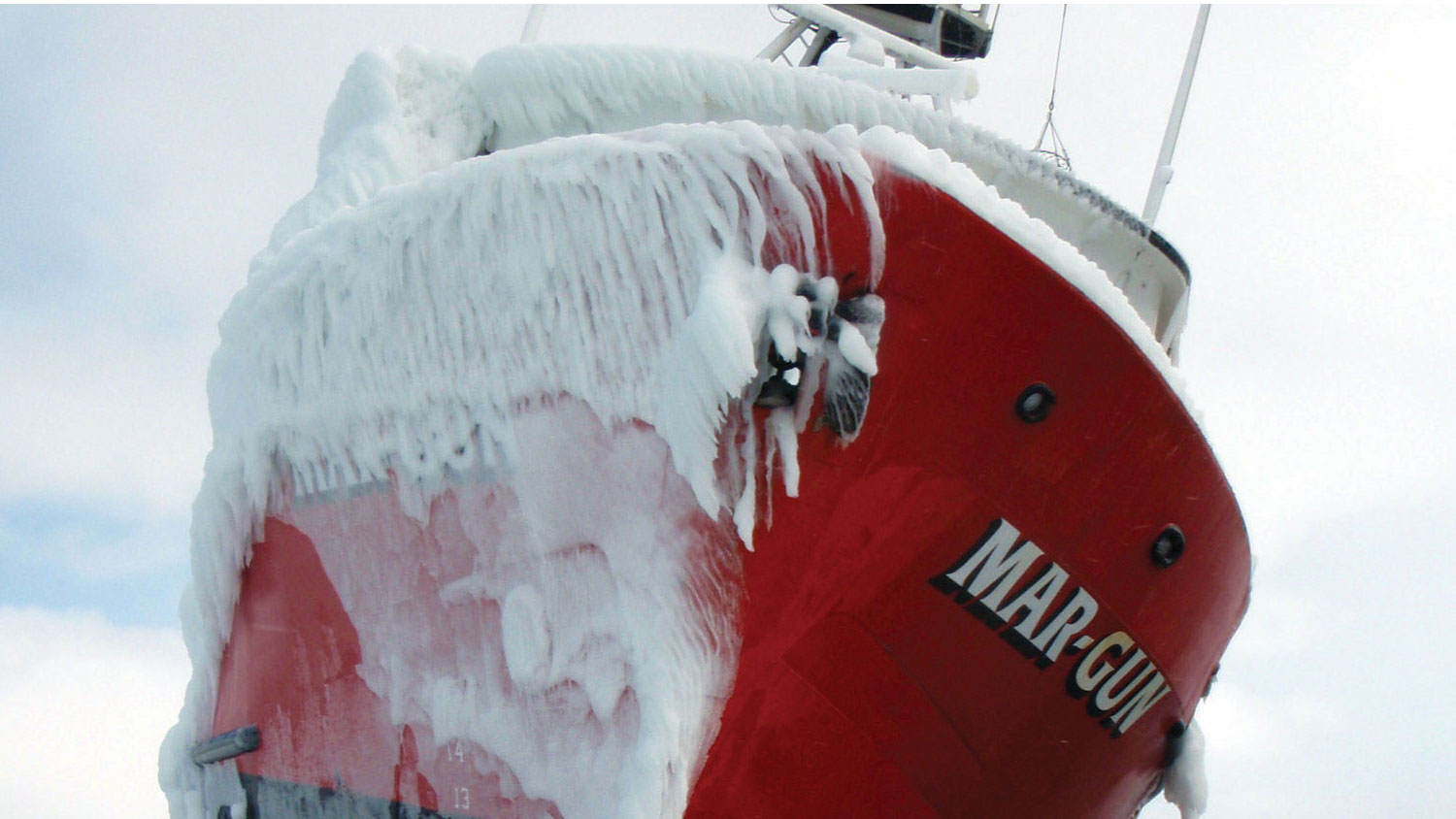
Fishing vessel Mar-Gun grounded on St. George Island in the Bering Sea. Ice accumulated on its starboard side. Freezing temperatures and sea spray can also create structural icing during transit that can be dangerous for a vessel’s stability and crew safety.
This brief examines the risks posed by increasing vessel traffic and outlines a series of mitigation measures that authorities can implement to protect all those who depend on the Bering Strait—wildlife and indigenous communities, as well as ships and their crews.
Risks from increasing vessel traffic
Cargo ships, tankers, barges, and other vessels navigating the Bering Strait pose numerous threats to its vibrant ecosystem and to the indigenous communities that depend on it. Potential risks associated with vessel traffic include:
- Air pollution and discharges of oil, trash, and sewage.
- Noise that can alter marine mammals’ behavioral and migratory patterns.
- Direct strikes on marine mammals, such as the slow-moving bowhead whale, particularly during its twice-yearly migration through the strait.
- Interference with subsistence activities and the safety of indigenous hunters, who travel as far as 100 miles from shore in small open skiffs.
- Accidents, loss of steerage, and running aground, which can place the personnel on board in danger.
Resources for safer travel
Information for mariners traveling the Bering Strait is outdated and incomplete. Ensuring that vessels have access to vital and reliable data about conditions in the Bering Strait would help to prevent accidents and to improve compliance with routing and other regulations. U.S. officials could improve the availability of this critical knowledge by:
- Updating hydrographic charting. Charts provide a variety of information for mariners, including seafloor characteristics, water depth, coastlines, and aids to navigation. Hydrographic charts in the Bering Strait and Arctic Ocean are inadequate, and those that exist are outdated, with the majority predating 1970.1 In a recent report, the U.S. Committee on the Marine Transportation System stated that "less than one percent of navigationally significant Arctic waters have been surveyed with modern technology to determine depths and depict hazards to navigation."2
- Adding aids to navigation. Navigational aids—including lighthouses, signs or beacons, and buoys—provide vessels with essential information such as direction, marine hazards, and location. Aids to navigation are meant to be used in conjunction with a nautical chart.
- Improving weather forecasting. Information about weather, sea ice, and sea state is critical to safe voyage planning in Arctic waters, but it is not widely available. Improving forecasting is listed among the top priorities in the U.S. National Oceanic and Atmospheric Administration’s “Arctic Vision & Strategy” document.3
Prevention and mitigation measures
The growth in shipping in these rough and poorly charted waters makes this a critical moment for the United States to begin developing appropriate standards of care—“rules of the road” for vessel traffic in Arctic waters. Few regulations currently guide vessels through the Bering Strait. Ships traversing U.S. waters without coming from or stopping at an American destination are not subject to U.S. laws. These ships are referred to as vessels in innocent passage. The only way to regulate these vessels is through the International Maritime Organization. Developing international regulations is a long and uncertain process, but there is an opportunity to develop federal rules for U.S.-regulated vessels traveling the Bering Strait.
 © 2009 National Geographic
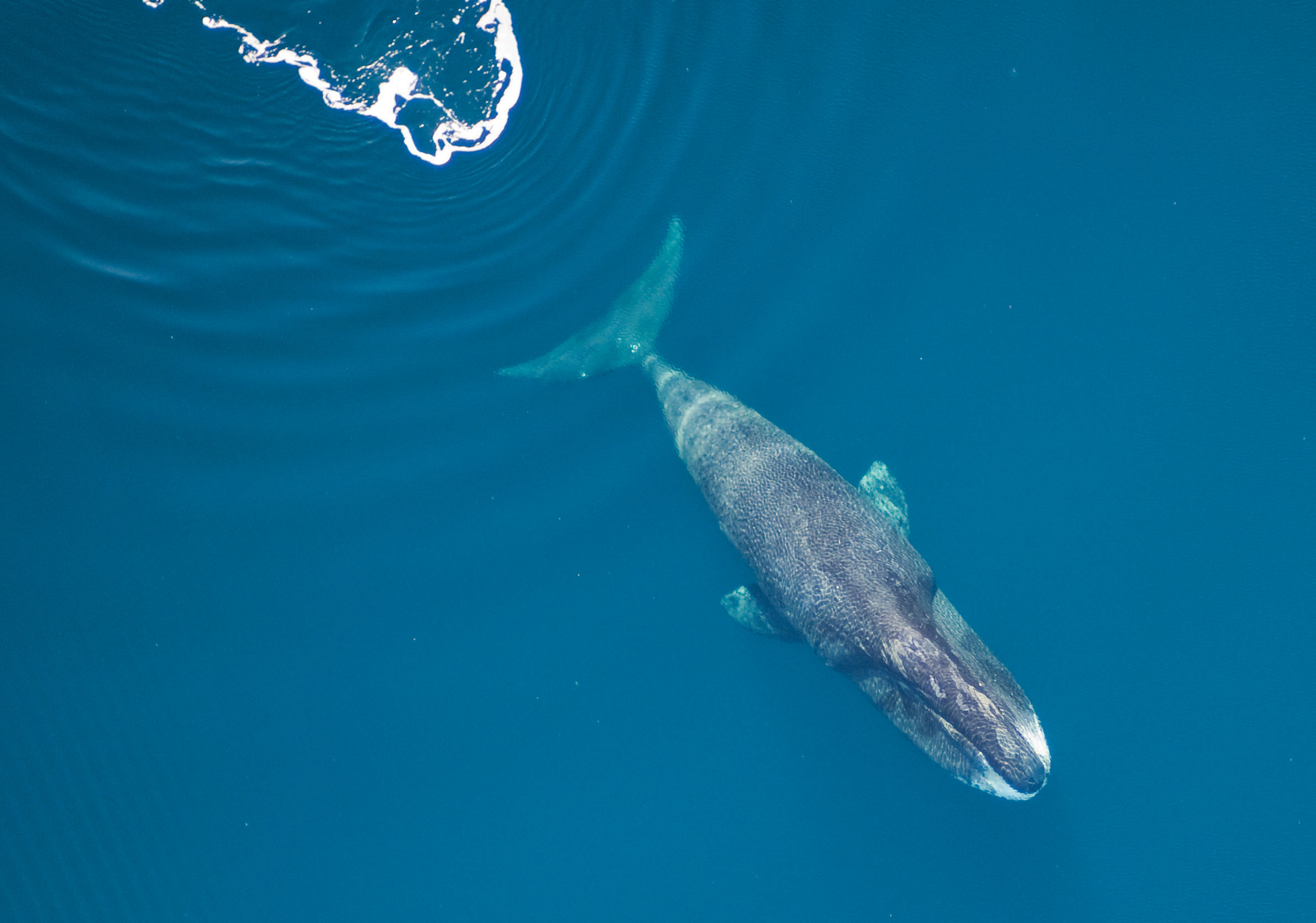
Large slow-moving whales such as grey and bowheads (shown) are especially at risk of vessel strikes.
Below are recommendations for federal standards to ensure safer transport and enhanced emergency preparedness.
Routings
For ships under its jurisdiction, the United States should designate clear rules of the road for passage through the Bering Strait, including:
- Speed limits. In areas with limited room to maneuver and avoid hazards, speed restrictions relative to the water current can greatly reduce collisions and other risks. For example, whales are far less likely to be killed by large vessels (cargo ships, tankers, large cruise liners) traveling 12 knots or slower.4
- Vessel traffic lanes (or shipping lanes). Shipping lanes help prevent accidents, such as collisions and grounding in hazardous or sensitive marine areas, by establishing regular, predictable traffic patterns.
- Areas to be avoided. If shipping lanes show passing vessels where to go, “areas to be avoided” tell them where they should never go. These areas may be designated because of marine hazards, such as shoals or strong currents. In a remote region such as the Bering Strait, they may also be used to keep sufficient space between vessels and shorelines to reduce the chance that a disabled vessel drifts ashore before help can arrive. They may also be designated for environmental or cultural reasons, such as protecting important hunting areas, wildlife migration routes, large congregations of marine mammals, and feeding grounds. These areas should be determined in close collaboration with local communities and subsistence hunters.
Mandatory vessel tracking, monitoring, compliance, and communication
Many vessels larger than 65 feet are required to have an automatic tracking system known as an Automatic Identification System, or AIS,5 which allows their position, speed, cargo, destination, and other information to be monitored. To make full use of this technology, U.S. regulators should require:
- AIS to be activated on all vessels greater than 30 feet under U.S. jurisdiction.
- Participation in a vessel traffic monitoring, compliance, and communication system. AIS technology,
if installed on every vessel, could support a three-way active vessel traffic monitoring, compliance, and communication system that would connect each commercial ship with the U.S. Coast Guard or a designated third party (such as the Marine Exchange of Alaska) and with local communities. Such a system would involve real-time tracking of vessels, via AIS and satellite, and would allow the Coast Guard or the designated intermediary to ensure that vessels are in compliance with regulations.
This system could require that vessels announce when they enter and leave designated areas. It could also provide vessels with important information on current weather conditions; possible hazards, such as ice; and the presence of hunters in small boats or large congregations or migrations of marine mammals. For the system to be effective, local communities must have the technology and training they need to communicate effectively.
Emergency prevention and preparedness
Even with the best prevention, accidents can happen; that’s why surrounding communities need to be prepared. Preparedness includes plans, adequate resources, and training to respond to a variety of emergencies in Arctic conditions, including search-and-rescue and oil spill response. The Bering Strait’s remote location and lack of major infrastructure, including airports, docks and ports, and roads, are likely to delay and complicate access to an emergency. Only one U.S. Coast Guard classified oil spill removal organization covers the Aleutian Islands and Bering Strait region. To bolster emergency preparedness in the area, U.S. officials can:
- Increase vessel planning, prevention, and response capacity. Most vessels over 400 gross tons that do business in the United States are required to have a vessel response plan and access to oil spill response, salvage, and marine firefighting resources. In Alaska, however, due to the remote location and lack of readily available equipment, vessels are allowed to meet Coast Guard-approved alternative planning criteria, which have been approved for a two-year period. The currently approved criteria, administered by the Alaska Maritime Prevention and Response Network, focus on marine domain awareness and contracts with oil spill removal organizations, with improved spill prevention and response capability to be phased in.
To be effective and eventually meet national response requirements, fees assessed to vessel owners should be increased to cover the cost of spill response equipment, tugs, and trained personnel. An example of a successful fee-based structure is a Washington state program in which membership covers the cost of vessel compliance and includes funding for a strategically staged tug to respond to emergencies.
- Train community first responders. Travel in the Bering Strait region is often hampered by bad weather or other logistical delays. During an emergency, time is critical for rescue efforts and protection of important areas from oncoming oil. Local communities and subsistence hunters have extensive and valuable knowledge of weather and water conditions, sensitive areas, and wildlife. Before professional oil spill responders or the Coast Guard arrive, community members will be the first on scene and should have access to and be trained to use equipment to protect their coastline or offer assistance to a person in distress.
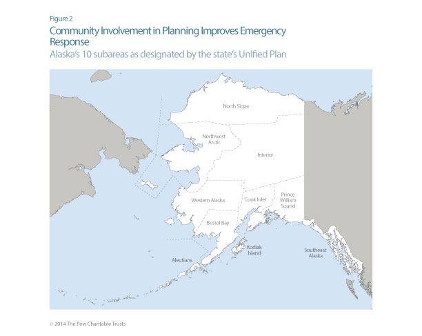
- Update subarea contingency plans. Under the National Response Plan and Alaska’s Unified Plan, the state is divided into 10 subareas. (See Figure 2.) Subarea contingency plans are meant to provide community contacts and a list of resources available to respond to an oil spill. After the massive 2010 Gulf of Mexico oil spill, the Coast Guard and U.S. Environmental Protection Agency renewed efforts to update local plans. The subarea plans that cover Alaska’s Arctic waters—North Slope, Northwest Arctic, Western Alaska, Bristol Bay, and Aleutian Islands—still have planning and resource gaps.6 These plans should be updated every few years through a meaningful public process and reflect local knowledge and protection priorities. To be effective, plans should be enhanced by industry- and state-funded response equipment and community member training, and include response tactics proved through field tests and on-water drills.
 Community involvement
Local communities should be actively involved and play a leadership role with other stakeholders in any of the efforts discussed above. Options include creation or expansion of:
- Arctic Waterways Safety Committee. Modeled on the harbor safety committees found at many U.S. ports, this committee would be responsible for recommending actions to improve safety, security, mobility, and environmental protection of the waterway.
- Regional citizens’ advisory councils.These have been effective in providing advice to industry on spill prevention and response.
- Area committees. These groups were established to provide input to subarea planning processes. They should be enhanced to ensure full participation in planning for spills.
- Advisory panels to inform alternative planning criteria approved for Arctic waters.These groups provide a venue for public input on measures approved in lieu of regulatory requirements and on priorities for improving response capability.
Other options, or combinations of these options, might exist; however, what is most important is that the interested public—particularly the people who live in affected communities—must play a role in policy development and implementation.
ENDNOTES
1 Lt. Matthew Forney, National Oceanic and Atmospheric Administration, Office of Coast Survey
(presentation at the Bering Strait
Maritime Symposium, Nome, Alaska, Feb. 5–6, 2013),
http://seagrant.uaf.edu/conferences/2013/bering-strait-maritime/program.php.
2 U.S. Committee on the Marine Transportation System, U.S. Arctic Marine Transportation
System: Overview and Priorities for Action 2013
(2013),
http://www.cmts.gov/downloads/CMTS_Draft_Arctic_MTS_Overview_and_Priorities_Paper_for_Public_Comment
-Feb2013.pdf.
3 Priorities include forecasting sea ice, strengthening foundational science to understand and
detect Arctic climate and ecosystem changes, improving weather and water forecasts and warnings,
enhancing international and national partnerships, improving stewardship and management of ocean
and coastal resources in the Arctic, and advancing resilient and healthy Arctic communities and
economies. Available at http://www.arctic.noaa.gov/docs/NOAAArctic_V_S_2011.pdf.
4 Angelia S.M. Vanderlaan and Christopher T. Taggart, “Vessel Collisions With Whales: The
Probability of Lethal Injury Based on Vessel Speed,” Marine Mammal Science 23 (2007): 144–156.
5 33 CFR § 164.46,
http://www.gpo.gov/fdsys/pkg/CFR-2010-title33-vol2/pdf/CFR-2010-title33-vol2-sec164-46.pdf.
6 Arctic Research Policy Act of 1984, Section 112. “As used in this title, the term ‘Arctic’
means all United States and foreign territory north of the Arctic Circle and all United States
territory north and west of the boundary formed by the Porcupine, Yukon, and Kuskokwim Rivers; all
contiguous seas, including the Arctic Ocean and the Beaufort, Bering and Chukchi Seas; and the
Aleutian chain.”


ADDITIONAL RESOURCES

Article

Quiz