Ten ‘Wild’ Features of Manitoba’s Boreal Forest
In Canada, celebrating the natural value of an intact landscape
The Canadian province of Manitoba has long been defined in popular imagination by the prairie landscapes of its southern region. The capital, Winnipeg, was the jumping-off point for 19th-century Europeans heading west to explore and settle the Great Plains. Manitoba’s official flower is the prairie crocus, and its provincial symbol is the bison, an icon of the Great Plains.
But more than three-quarters of Manitoba is actually boreal forest, part of the largest intact forest ecosystem remaining on the planet—the 1.2 billion acre (485,000 hectare) Canadian Boreal. It is a place of remarkable ecological and cultural diversity. Governments, conservation groups, Indigenous Nations, and industry are working together to protect this landscape. And there is good news: Significant progress is being made on forest conservation here. In February 2015, the provincial government held a “boreal summit” in the northern community of The Pas to launch talks on how best to balance conservation and sustainable development in the forest region.
To celebrate this step forward, we have compiled 10 remarkable features—big and small—of Manitoba’s boreal region:
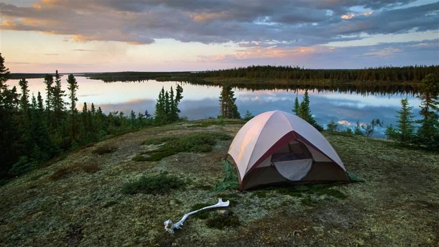 Tim Hauf
The sun sets on a campsite overlooking the Seal River in northern Manitoba.
Size matters
If Manitoba’s boreal region were its own country, it would be larger than Japan, Sweden, or Spain. It is bigger in area than California, and every U.S. state except Alaska and Texas. The boreal covers 140 million acres (56 million hectares) in Manitoba. No other Canadian province or territory includes four of the country’s major boreal ecozones—Boreal Plains, Boreal Shield, Hudson Plains, and Taiga Shield. Remarkably, 80 percent of the region—roughly 115 million acres (46.5 million hectares)—is still highly intact and free from development. This gives Manitoba a chance to carefully plan a future for the region that balances economic development and environmental protection. It is an opportunity for large landscape conservation already lost in many other places around the globe.
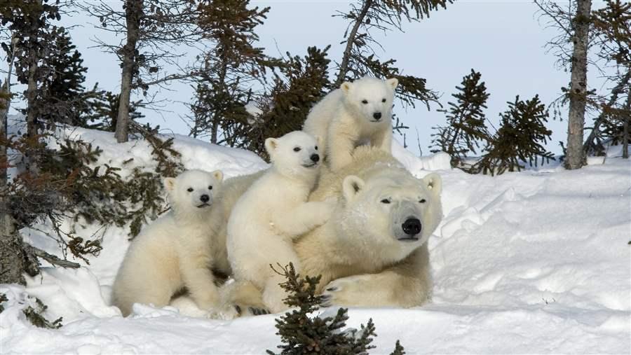 Getty Images
Polar bear mother and cubs at Wapusk National Park in northern Manitoba.
Polar bear nursery
Manitoba contains some of the largest, southernmost, and most important polar bear habitat on the planet. Throughout the brief, cool summers along the coast of Hudson Bay, thousands of visitors from around the world descend on the remote tundra town of Churchill to glimpse these charismatic Arctic mammals. But each fall, a less-observed ritual occurs. Hundreds of polar bear sows move inland to give birth to their cubs in earthen and snow-covered dens on the solitary edges of Manitoba’s boreal forest. Although polar bears spend several months a year on sea ice, their maternal dens in northern Manitoba can be found up to 93 miles (150 kilometers) inland, in the transition area between boreal and tundra.
A 2005 study of 101 polar bear sites in Manitoba found that females make their dens primarily in peat banks along creeks, rivers, and lakes sheltered by spruce and tamarack. The study indicated spruce tree roots play an “important role in stabilizing” the ceilings of earthen polar bear den sites. The animals begin digging these earthen dens before snowfall, then use snowbanks to make late-winter additions to their frosty homes. This habitat, considered the world’s largest denning area for polar bears, is vital to the long-term health of this iconic northern species.
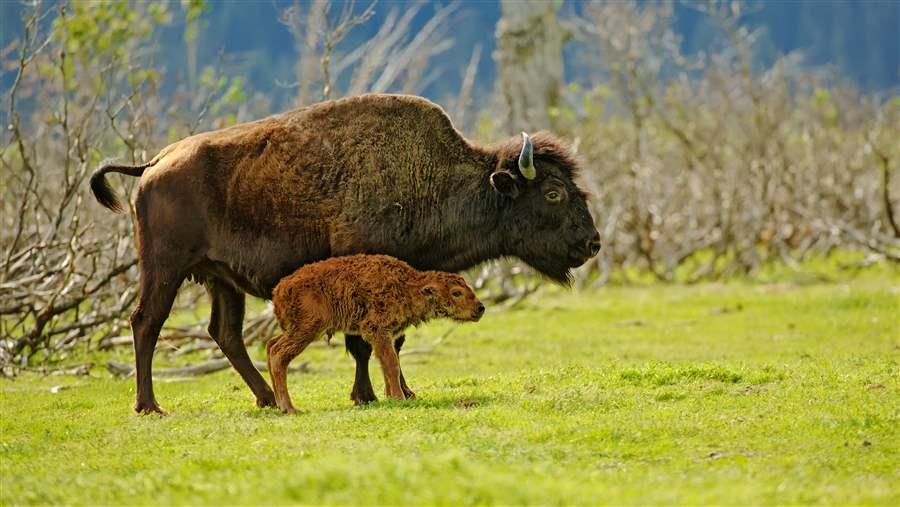 Getty Images
Wood bison have a new 250,000-acre refuge in Manitoba's boreal forest.
A home where the (wood) buffalo roam
Deep in the boreal forest about 215 miles (346 kilometers) northwest of Winnipeg, North America’s largest land mammal holds domain over a 250,000-acre (100,300 hectare) forest wilderness. Chitek Lake Provincial Park, officially designated in 2014, is home to the only wild population of wood bison in the province. The new park will protect an area larger than Badlands National Park in South Dakota. Its creation caps a decades-long effort to establish an area where wood bison, listed as a threatened species in Canada, could again thrive in the wild. Canada’s population of wood bison was once estimated at 170,000. The Canadian government estimates that there are just over 7,000 today in nine isolated subpopulations nationwide. Wood bison, taller and heavier than the plains bison subspecies, once roamed over large sections of Alaska. No free-ranging population exists in the United States, although there are plans to release some into the wild this year.
In Canada, Manitoba is writing its own success story. In 1991, the province’s Conservation and Water Stewardship department released 13 wood bison into the central area between Lake Winnipeg and Lake Winnipegosis, two of the largest freshwater lakes in North America. The herd has grown to more than 300 animals.
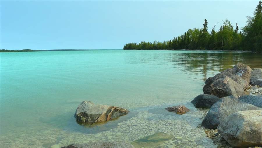 Canadian Parks and Wilderness Society
The turquoise waters of Little Limestone Lake, Manitoba.
A Caribbean-colored aquatic gem
Little Limestone Lake is tiny by the standards of boreal region behemoths such as neighboring Lake Winnipeg, the planet’s 10th‑largest freshwater lake. But, at 10,000 acres (4,000 hectares) in size, Little Limestone still boasts its own heavyweight title as the world’s biggest color-changing “marl” lake. Each summer, when temperatures rise, calcite from eroded limestone is released from the lake’s bottom, forming marl crystals. The waters undergo a stunning transformation—turning from clear to sparkling turquoise or robin’s egg blue. The change makes Little Limestone unique and gives northern Manitoba residents “a piece of the Caribbean” amid a landscape of Canadian shield, jack pine, and spruce trees. The Manitoba government created a park around the lake’s shoreline, and Little Limestone has been designated as an International Union for Conservation of Nature protected area. The Mosakahiken Cree First Nation and provincial conservation groups are working to have the park’s perimeter expanded to keep its waters safe from potential industrial development.
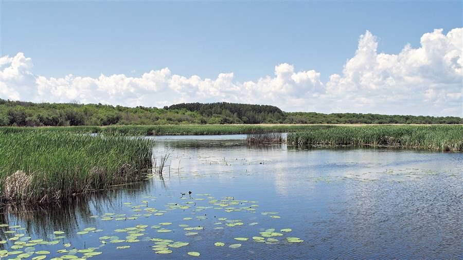 Ducks Unlimited Canada / www.ducks.ca
The Saskatchewan River Delta provides vital habitat for waterfowl and migratory birds.
Saskatchewan River Delta
The Saskatchewan River Delta in Manitoba’s boreal lowlands is one of the largest inland deltas in the world, created with the retreat of glacial Lake Agassiz more than 10,000 years ago. Sediment deposited from the Saskatchewan River over the centuries is 59 feet (18 meters) thick in some areas. The delta is a globally significant haven for migratory birds and waterfowl, and has been designated by BirdLife International as an Important Bird Area. Nearly 500,000 ducks nest in the Saskatchewan River Delta each year; more than 200 bird species breed within or rely on the region during migration. The delta spans the Manitoba-Saskatchewan border and stores more than 175 million tons of carbon. That’s about eight times the amount of greenhouse gases emitted each year in Manitoba. The area is an important “reservoir of biodiversity”—over 45 fish species and more than 40 mammals are known within the region, according to Ducks Unlimited Canada and the Boreal Songbird Initiative. Although several conservation areas have been established within the delta, the Manitoba government has identified a need for additional protected areas.
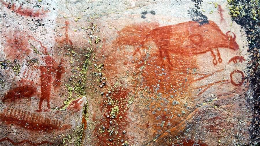 Tim Hauf
Pictographs show a bison and a human figure at Artery Lake in the boreal forest of eastern Manitoba.
Ancient pictographs
It’s a human history, painted in red. On rock outcroppings along several boreal rivers and lakes in northern Manitoba, drawings of people, bison, birds, trees, and human implements tell stories of early indigenous culture in the region. Some of the most spectacular examples of this prehistoric rock art, made in red ochre, can be found along the Bloodvein River, part of the proposed Pimachiowin Aki World Heritage Site east of Lake Winnipeg, and at Tramping Lake along the Grass River farther north. At the Tramping Lake site, pictographs have been found on several rock faces and are estimated to be between 1,500 and 3,000 years old. They were likely painted by Ojibway or Cree artists, working from canoes to reach their granite canvasses.
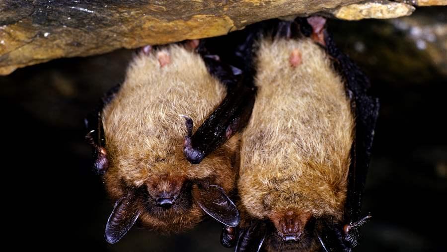 Getty Images
Endangered little brown bats hibernate in Manitoba's Walter Cook Caves.
Walter Cook Caves Ecological Reserve
One of the newest protected areas within the boreal forest of Manitoba, this 7,900-acre (3,200 hectare) ecological reserve protects a unique complex of limestone caves and sinkholes that provides habitats for boreal flora and fauna. It includes the northernmost hibernation sites in Canada for the little brown bat. The caves—including the colorfully named Iguana Crypt, 4-eyed, and Ice Cascade—have been created over time as water dissolved limestone and dolomite. They are also hibernation spots for black bears. Sandhill cranes use the reserve as a migratory stopover.
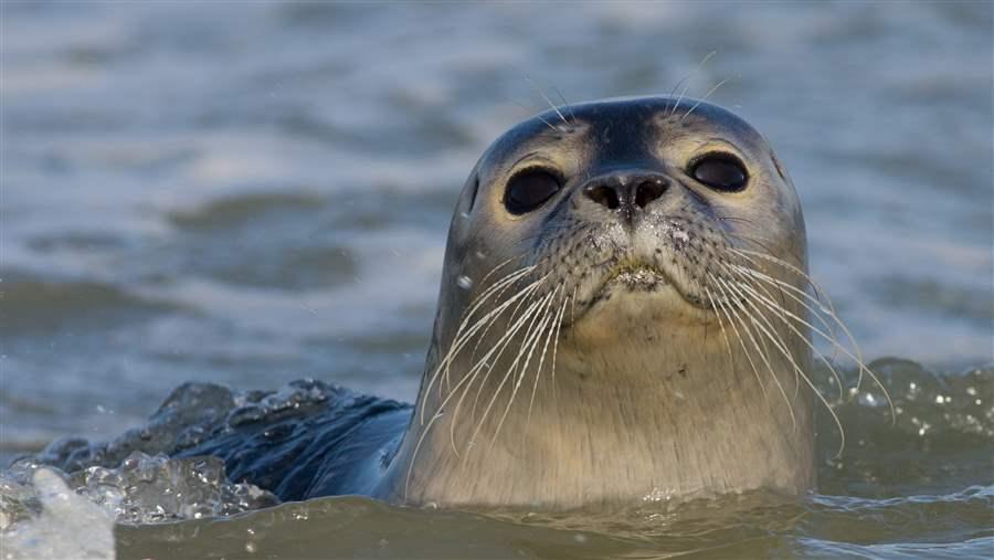 Getty Images
Harbor seals will swim as far as 125 miles up Manitoba's Seal River from Hudson Bay.
Harbor seals on the Seal River
Along with polar bears and beluga whales, harbor seals are among the best known animals along the northern Manitoba coastline. But harbor seals, like polar bears, also have a strong connection to the boreal forest. According to the Canadian Parks and Wilderness Society, these “ambassadors of the ocean” swim roughly 125 miles (200 kilometers) up the aptly named Seal River into the boreal wilderness. “In this location, the river’s namesake animal likely strays further from their marine environment than anywhere else on Earth,” says the CPAWS. The Seal River is one of only two major free-flowing rivers in Manitoba. It is the most untouched by humans, inaccessible to almost everyone but the hardiest outdoor adventurer. In addition to hosting traveling brigades of harbor seals, the Seal River’s estuary provides important calving grounds for 3,000 belugas each year.
 Ron Thiessen/Canadian Parks and Wilderness Society
Manitoba's recovery strategy for woodland caribou is considered the strongest in Canada.
Caribou conservation
Much like hockey, Mounties, and maple syrup, caribou are central to the Canadian identity. Featured on Canada's 25-cent coin since 1937, these iconic animals are also key indicators of the health of the nation’s 1.2 billion acre boreal forest ecosystem. Woodland caribou once ranged south from Canada into Maine, Minnesota, Wisconsin, and New Hampshire, but they have lost half their traditional range in the past century. Listed by the U.S. Fish and Wildlife Service as endangered in 1983, woodland caribou in the lower 48 states are now found in only three counties in northern Idaho and Washington. The Canadian government lists boreal-dwelling woodland caribou as threatened and has found that populations in 37 of 51 ranges have fallen below sustainable levels. Manitoba is one of the few jurisdictions where the prognosis for boreal-dwelling caribou is improving, because of efforts to protect intact boreal habitat. Manitoba’s draft caribou recovery strategy, released in April 2014, tops all others in the nation with a proposal to protect and manage 65 to 80 percent of intact suitable boreal caribou habitat.
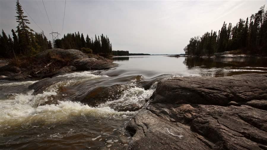 Shutterstock
The Sasagin Rapids on the Grass River in northern Manitoba.
A blue mosaic of water and wetlands
Canada’s boreal forest region is renowned worldwide as the largest and cleanest source of unfrozen freshwater on Earth. Manitoba has more than 8,000 lakes that are 247 acres (1 square kilometer) in size or larger. Most are relatively undisturbed. The province’s “Great Lakes”—Winnipeg, Winnipegosis, and Manitoba—are among the largest freshwater lakes in the world. The province is also home to world-class wetlands, with bogs, fen, marsh, and swamp covering roughly 49 million acres (20 million hectares) of the boreal region. In a recent report, Ducks Unlimited Canada and the Boreal Songbird Initiative said this “vast network of blue” in Manitoba provides “ecological insurance for future generations.”
Sources: Ducks Unlimited Canada, Canadian Parks and Wilderness Society-Manitoba, Boreal Songbird Initiative, Government of Manitoba, Government of Canada, Polar Bears International, Canadian Heritage River Systems, Canadian Geographic, National Geographic, and Winnipeg Free Press


ADDITIONAL RESOURCES

Article

Article